Rock Lititz Floodplain Restoration
Rock Lititz prides itself on being a “one-stop-shop” for production needs in the live show industry. Located on a 96-acre farm in scenic Lancaster County, Pennsylvania, the Rock Lititz Studio aims to be the epicenter of the rock concert business where bands can set up and test concerts before they go on tour. Over the past few years, their campus has grown to include a restaurant, hotel, walking trails, and yoga studio. It also serves as a venue for community events such as local art shows.
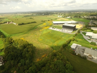
Before Rock Lititz Properties could begin construction to expand their production community, multiple environmental issues had to be addressed. The area suffered from frequent flooding, and the Santo Domingo Creek – a tributary to Lititz Run that flowed through the property – had become severely impaired due to historical land use. The stream channel had been re-routed long ago to accommodate farming operations, and the realignment resulted in the deposition of legacy sediment on the valley floor. Years of streambank erosion and streambed degradation allowed this polluted, nutrient-rich sediment to travel downstream and severely impact local water quality.
To help address these issues, Rock Lititz Properties worked with the local municipality (Warwick Township) to identify how to best address their stormwater management needs while also considering the regional implications of their work. Rock Lititz Properties contracted with LandStudies, Inc., a local landscape architect firm specializing in floodplain restoration and regional stormwater solutions, to develop a uniquely regional approach to restore the 17-acre floodplain running through the site. The restoration effort utilized several sustainable site design elements to enhance floodwater infiltration, restore the degraded riparian corridor, and ultimately reduce flooding and pollutant loads to the Lititz Run Watershed.
The design included the restoration of over 3,000 linear feet of the Santo Domingo Creek back to its historic condition by removing legacy sediment from the valley bottom. This increased the overall floodwater storage potential of the area, reducing the need for traditional stormwater basins that take up valuable land prime for development. By utilizing the restored floodplain for stormwater management, nine acres of land were freed for development with the recovered land estimated to be worth $3.1 million. In addition to decreased flooding, the restoration also improved groundwater recharge in an identified critical aquifer recharge area, thereby, increasing the community’s valuable potable water supply. Streambank stabilization reduced erosion, and the additional native vegetation and hundreds of planted trees improved bio-diversity while creating recreational and aesthetic benefits for the community and habitat for local wildlife.
According to Kelly Gutshall, President of LandStudies, Inc., the goal of the project was to incorporate the concept of “economic ecology,” which emphasizes the importance of both economic and environmental gains – and the possibility of the two working symbiotically. Between the increased economic opportunities afforded by the maximized acreage for development and the environmental benefits gained from sediment and nutrient load reductions, aquifer recharge enhancements, and wildlife habitat creation, Gutshall sees the project as a huge success.
Visitors to the campus can see that business is flourishing. Nearly 30 different companies comprise the Rock Lititz Community. There are plans for additional walking trails, a cross track course, and a 139-room hotel is scheduled to open in the fall of 2018. The Studio is busy with music productions, and the venue is a sought after destination for international entertainers as well as local community events.
For more information about this project, visit our case story map: https://mostcenter.org/case-story-content/rock-lititz-floodplain-restor….
Legacy Sediment
Sediment that eroded from upland areas after the arrival of early settlers and during centuries of intensive land use. This nutrient-rich sediment deposited in valley bottoms along stream corridors, burying pre-settlement streams, floodplains, wetlands, and valley bottoms. Legacy sediment continues to impair the hydrologic, biologic, aquatic, riparian, and water quality functions of modern environments today.
-Source: PA Department of Environmental Protection